
|
 |
 |
 Secrets of Ancient Navigation
by Peter Tyson Oak and triple bronze must have girded the breast of him"Aye, mate." One can almost hear the weary assent of countless a hoary sailor upon hearing these words of Horace, almost see the rheumy eye staring distantly as if at some ghost ship on the horizon that only he can see. For the old poet's words ring only too true. In the three or four millennia of seafaring before John Harrison came along, how could mariners know where they were going? The sea is literally without landmarks to guide by, a vast, featureless emptiness ready and more than willing to swallow up the lost and unlucky, leaving no trace save the awful memories of those who survived them. The first seafarers kept in sight of land; that was the first trick of navigation. Follow the coast. To find an old fishing ground or the way through a shoal, one could line up landmarks, such as a near rock against a distant point on land; doing that in two directions at once gave a more or less precise geometric location on the surface of the sea. Sounding using a lead and line also helped. "When you get 11 fathoms and ooze on the lead, you are a day's journey out from Alexandria," wrote Herodotus in the fourth century B.C. The Greeks even learned to navigate from one island to the next in their archipelago, a Greek word meaning "preëminent sea." They may have followed clouds (which form over land) or odors (which can carry far out to sea). But what if land were nowhere nearby? The Phoenicians looked to the heavens. The sun moving across the commonly cloudless Mediterranean sky gave them their direction and quarter. The quarters we know today as east and west the Phoenicians knew as Asu (sunrise) and Ereb (sunset), labels that live today in the names Asia and Europe. At night, they steered by the stars. At any one time in the year at any one point on the globe, the sun and stars are found above the horizon at certain fixed "heights"—a distance that mariners can measure with as simple an instrument as one's fingers, laid horizontally atop one another and held at arm's length. The philosopher Thales of Miletos, as the Alexandrian poet Kallimachos recorded, taught Ionian sailors to navigate by the Little Bear constellation fully 600 years before the birth of Christ: Now to Miletos he steered his courseThe Norsemen had to have other navigational means at their disposal, for in summer the stars effectively do not appear for months on end in the high latitudes. One method they relied on was watching the behavior of birds. A sailor wondering which way land lay could do worse than spying an auk flying past. If the beak of this seabird is full, sea dogs know, it's heading towards its rookery; if empty, it's heading out to sea to fill that beak. One of the first Norwegian sailors to hazard the voyage to Iceland was a man known as Raven-Floki for his habit of keeping ravens aboard his vessel. When he thought he was nearing land, Raven-Floki released the ravens, which he had deliberately starved. Often as not, they flew "as the crow flies" directly toward land, which Raven-Floki would reach simply by following their lead. 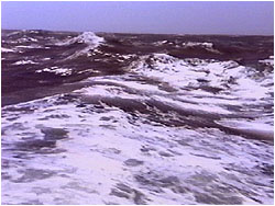 Heeding the flightpaths of birds was just one of numerous
haven-finding methods employed by the Polynesians, whose
navigational feats arguably have never been surpassed. The
Polynesians traveled over thousands of miles of trackless
ocean to people remote islands throughout the southern
Pacific. Modern navigators still scratch their heads in
amazement at their accomplishment. Like Eskimos study the
snow, the Polynesians watched the waves, whose direction and
type relinquished useful navigational secrets. They followed
the faint gleam cast on the horizon by tiny islets still out
of sight below the rim of the world. Seafarers of the Marshall
Islands built elaborate maps out of palm twigs and cowrie
shells. These ingenious charts, which exist today only in
museums, denoted everything from the position of islands to
the prevailing direction of the swell.
Heeding the flightpaths of birds was just one of numerous
haven-finding methods employed by the Polynesians, whose
navigational feats arguably have never been surpassed. The
Polynesians traveled over thousands of miles of trackless
ocean to people remote islands throughout the southern
Pacific. Modern navigators still scratch their heads in
amazement at their accomplishment. Like Eskimos study the
snow, the Polynesians watched the waves, whose direction and
type relinquished useful navigational secrets. They followed
the faint gleam cast on the horizon by tiny islets still out
of sight below the rim of the world. Seafarers of the Marshall
Islands built elaborate maps out of palm twigs and cowrie
shells. These ingenious charts, which exist today only in
museums, denoted everything from the position of islands to
the prevailing direction of the swell.
The greatest advance in navigation came with the compass. The Chinese apparently knew about the powers of magnetism as early as the third millennium B.C., when, historians tell us, one army defeated another after the battlefield had become enveloped in dense fog by using a device known as a "point-south carriage." This was a standard carriage for carrying royalty with a small, rotating figure mounted on the front, which by magnetism always pointed south. (The Chinese chose to have the arrow point south rather than north.) But no one seems to have manipulated the lodestone for sea navigation until early in the present millennium. The first mention of the compass in the West comes from the Englishman Alexander Neckham, who wrote in 1187 that "sailors use a magnetic needle which swings on a point and shows the direction of the north when the weather is overcast." Despite its usefulness, the compass took a long time to come into wide use, as many seamen thought it operated by black magic. (Hence the invention of the binnacle, in which sea captains could hide their recondite instrument from the suspicious eyes of the crew.) In the meantime, sailors relied on natural forces they could readily comprehend. One of these was currents. From time immemorial, journeys have been made or broken by these undersea winds. The western-trending currents of the Indian Ocean, for one, are likely responsible for the Indonesian-based race of Madagascar, an African island 4,000 miles from the nearest bit of Indonesia. Similarly, the clockwise currents in the North Atlantic helped doom one of the greatest land scams in history: Erik the Red's colonization scheme for the island he cleverly dubbed "Greenland." Of the 25 ships that sailed west from Norway in the year 990, only 14 arrived. The father of those North Atlantic currents—the Gulf Stream—was named by none other than Benjamin Franklin. While deputy Postmaster-General of Great Britain in the 18th century, Franklin noticed that his mail ships to the American colonies took longer than whaling ships. Questioning whalers, he learned of a powerful current originating from the Gulf of Mexico—hence his name for it—and sweeping northeast into the North Atlantic (and, incidentally, giving the British Isles a climate positively balmy for such a northern latitude). Like currents, trade winds have always been important to mariners. Those blowing heads on yellowed old maps were not mere decoration. In the Indian Ocean, for example, Indian traders over the ages have ridden the northeast monsoon to Africa in the cool, dry winter and taken the southwest monsoon back to the subcontinent in the hot, wet summer. To make their annual voyages from Tahiti to Hawaii, a journey of several thousand miles, the Polynesians hitched a ride on the prevailing south-easterly wind, setting a starboard tack and sailing northeast.
In the Middle Ages, sailors relied on the astrolabe, a disc of metal that one held suspended by a small ring. The disc had a scale with degrees and a ruler for measuring the height of an astronomical body. Other medieval mariners preferred the cross-staff, a T-shaped device whose base was held up to the eye. One measured the sun's height by pulling the slidable top of the T toward one's eye until the sun lay at the top and the horizon at the bottom. Since blindness resulted from frequent use, the explorer John Davis invented the back-staff in 1595, which enabled one to get the same measurement with one's back to the sun. The sextant was the most advanced of these devices, allowing users to determine their latitude to within a sea mile or two, even from a swaying deck.
There will come an age in the far-off years Peter Tyson is Online Producer of NOVA. Photos: (1,2) NOVA/WGBH; (3) Visuals Unlimited/Owon Gingerich. Great Challenge | GPS | Find Your Longitude Ancient Navigators | Resources | Teacher's Guide Transcript | Site Map | Longitude Home Editor's Picks | Previous Sites | Join Us/E-mail | TV/Web Schedule About NOVA | Teachers | Site Map | Shop | Jobs | Search | To print PBS Online | NOVA Online | WGBH © | Updated November 2000 |
 Statue of Ptolemy.
 The crossbar
 The sextant